Friday, September 30, 2016

Escape Routes

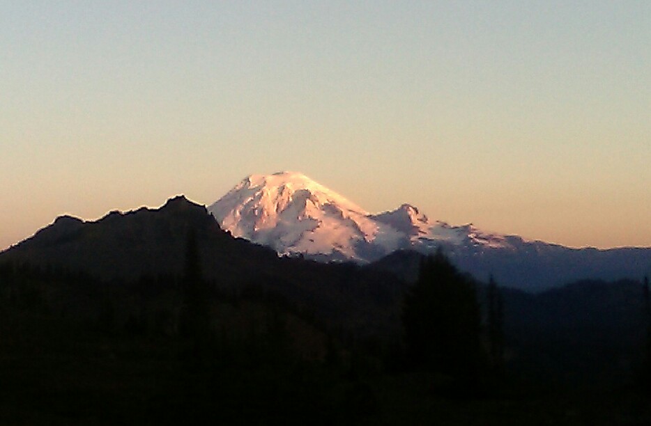
Status update: I am now writing from Stevens Pass, PCT mile 1462. The following 107 miles go through very remote wilderness close to Glacier Peak. The last five days were beautiful, sunny and mild; but more unsettled weather is expected to arrive tomorrow.
Here is the latest forecast:

And more detailed forecasts for 1500 m / 5000 ft elevation around Glacier Peak:


There is a chance of snow showers above 6000 ft elevation. The PCT only reaches 6000 ft in the highest passes. It is still good to be prepared for escape routes.

escape route 1: Go back to Stevens Pass. Good option if weather turns wintery before I reach mile 2480.

Escape route 2: Mile 2499, North Fork Sauk River trail. This trail descends quickly to lower elevation; it is 8 miles from PCT to a forest road, and 8 more miles to a paved road with hitchhiking possibility to civilization. Note: this is an emergency escape route for the case of snow.

Escape Route 3: Mile 2538, Suiattle River. The river valley is at low elevation of 3000 feet. It is 7 miles to a teailhead where I could get a ride if I'm lucky; and an extra 21 miles to a major highway. There's supposed to be a pit toilet at the trail head where I could stay dry in case of heavy rain.

Escape route 4: Stehekin, mile 2569. There is accommodation at the Stehekin Ranch 2.5 miles from the PCT. Also a bus goes twice, a day to the landing on shore of Lake Chelan with a lodge, post office, and bakery. A ferry boat goes in the afternoon from Stehekin Landing to Chelan. In Chelan I can catch a bus to Wenatchee with connection to Seattle. Stehekin is my most probable escape point and possible end point of my PCT hike, still allowing time for a quick weekend visit to see my friends in Utah before leaving the USA.
...
After Stehekin it's 80 more miles to Canada border across very high elevation... Not even thinking about that section. The ideal schedule would be reaching Stehekin on Wednesday afternoon. If I reach there, then I'll probably stay at the ranch in a warm and dry cabin and decide on next steps based on weather, time, and my feet.

Notice about my blog:
I am now about 8 days behind in my blog postings. The days are getting shorter and l have chosen to spend time eating huckleberries instead of writing. Also when the sun hides, my fingers get cold very fast while typing on cell phone keyboard. But I promise to catch up on my blog posts, either 6 days from now in Stehekin, or after I leave the trail. My maximum number of remaining days on the PCT is 9 days. On October 10th I must board the plane in Vancouver and exit America!

Tuesday, September 27, 2016

Day 146: Resupply Station and Rest Day at White Pass

Campsite under northern end of the Knife Edge ridge in Goat Rocks Wilderness - Village Inn Motel at White Pass
Mile 2277 - 2292
Total 15 miles

The night near the upper tree line just below the Knife Edge was cold, but it was dry. The large and scary looking storm cloud stopped its movement or it was redirected by the knife edge in another direction. In meadows and on exposed location it must have been below freezing, but the ground under the little group of trees where I camped stayed protected from frost. When I look out of my tent, the eastern sky is turning bright. Mount Rainier, the king watching over the PCT in Washington, is visible for a moment without clouds and with a fresh white snowy cap covering his entire summit.


The trail descends downhill into forest, crossing several meadows and streams. The soil is crunching under my shoes on the meadows and smoke is steaming from moist ground, lakes and tree branches as, the sun rises higher.


The well maintained path climbs up on a ridge, where Mountt Rainier can be seen again. Now the mighty volcano is covered by thick clouds. But near the trail it is sunny, a and I use the rare occasion to spread out and dry up my tent, sleeping bag and other wet items. I also cook a big lunch using up the rest of my rice supplies.


Soon after my lunch break I reach today's high point with views of the light blue colored Shoe lake. From there it is seven more miles mostly downhill to White Pass.


Passing a ski lift and little lakes, the trail enters old forest. I meet two hikers going south and a group of elk hunters with bows and arrows. The ground is covered with a half inch layer of hail. The thunderstorm from yesterday night was intense. I have been really lucky that it didn't reach my campspot last night.


Then I meet more hikers with tiny backpacks - a sure sign that civilization is near. Finally I hear the sound of cars ass thee trail emerges at a parking lot with information panels about wilderness ethics and poisonous mushrooms. From there it is just half mile on the road to the Cracker Barrel store where a package forwarded from Cascade Locks is waiting for me.


The store is still open and the package from my good friends Robert and Mary has arrived! It contains walnuts, almonds, raisins, black tea, flavored couscous, trail bars and all kinds of other goodies. The store also sells fresh fruit and fries. When I try to buy them my card is declined. But luckily I have the new phone and I can call the bank. Apparently they thought buying my tickets for Italy flight was a suspicious transaction and blocked my debit card. With the card working again, I order the fries and chat with other hikers and with two bikers, Dave and Kathy from Seattle who are on an eight week bike tour of Oregon and Washington. Time passes fast and it is almost 5:30. In an hour it will start getting dark. Some hikers are staying at the motel next door. I tell the bikers I need go get going and find a spot to camp before night kicks in. Or should I also stay in the motel? Then the bikers tell me: It is cold and wet outside and you should stay under a roof. We also are staying in the motel. We'll pay a motel room for you. I try to refuse but they insist and say I'll do thee same thing when the next opportunity arises. Thankful for the totally unexpected gift, I finally accept, and check in as comfortable motel room equipped with a little kitchen and a big tea pot.


I stay up late into the night, enjoying a hoit shower, drinking many cups of hot tea, measuring my supplies, and catching up on my blog writing. It is long after midnight when I finally snug in the warm and dry bed.

Sunday, September 25, 2016

Den 145: Kozí skály

Pod celtou u jezírka na okraji divočiny Goat Rocks - tábořiště pod severním koncem hřebene "Ostří Nože" ("Knife Edge")
Míle 2256 - 2277
Celkem 21 mil

Když ráno vykukuji ze stanu, už je bílý den. V noci jsem spal schoulený do klubíčka. Zůstávám ve spacáku a vařím černý čaj a poslední dva hrnky směsi ovesných vloček, rozinek a oříšků. Pak urychleně balím celtu a stan a svižně se vydávám na cestu. Noc byla skutečně mrazivá. Všude mimo les je tráva pokrytá jinovatkou a půda křupe pod nohama. Jsem rád, že jsem včera zvolil tábořiště pod hustými korunami smrků. Vystupuji na skalní hřbet, kde se ukazuje ranní sluníčko. Jako bájný král vysoko nad zalesněnými hřebeny trůní Mount Rainier s čepicí čerstvého sněhu.

Z hřbetu vede stezka dolů do mrazivé zalesněné kotliny s jezírky a močály. Na stezce nalézám pytlík rozinek s oříšky, který nejspíš někomu vypadl z kapsy během včerejšího deště. Pro mě je to vítaná posila a vzpruha.


Z kotliny trasa stoupá mírně vzhůru směrem na hlavní hřeben Kozích skal ("Goat Rocks"). Dokopec vítám, je dobrý na zahřátí. Také skalní srázy se začínají pomalu zahrivat. Z úbočí je vidět na jezerní kotlinu a na čerstvým sněhem posypaný vrchol Mount Adams, kolem kterého jsem včera procházel v husté mlze a dešti.


Sluníčka využívám k dlouhé sušicí pauze. Na palouku rozprostírám spací pytel, celtu, stan, mokré ponožky.. a mezitím vařím chutný oběd. Na dně batohu jsem objevil zbytek sušených fazolí a zeleniny z hajkr boxu, o kterých jsem netušil, že je ještě mám. Teď se mi náramně hodí :-)


Během dlouhé pauzy kolem mě prochází několik hajkrů, které jsem minul rano, když spali ve stanech nebo vstávali. Jedna z hajkerek mi prozrazuje čas: mohu tak nařídit hodinky v mobilu, který se mi včera po dešti řečeno po anglicku "zresetoval" na 1.1.1970 9:00. Kolem prochází i stará kamarádka a souputnice s přezdívkou "Monarch". Překvapivě jde od severu na jih; S vědomím, že v říjnu blízko Kanady možná už brzy hrebenovka zapadá sněhem, se u Kráterového jezera rozhodla přejet ke kanadské hranici a odtud se vrací zpět na jih do teplejších krajin. Já zatím ještě pokračuju na sever, vzhůru na hřeben nad hranici lesa.


V průsmyku Cispus Pass na hranici indiánské rezervace Yakama potkávám dobrovolníky pracující na údržbě stezky. Potvrzují, že mám štěstí na suché počasí; včera na hřebeni padal déšť se sněhem a foukala silná vichřice a museli se otočit čelem vzad a rychle sejít dolů zpátky do základního tábora. Šestihranné sloupy ve skalách prozrazují sopečný původ hornin.


Z průsmyku stezka míří dolů a sleduje vrstevnici rovnoběžně s hřebenem zhruba na horní hranici lesa. Ve svazích nad vodopády se pasou divoké horské kozy.


Ve tomto úseku je stezka vzorně upravena. Dobrovolníkům patří velký dík!


Následuje ostrý výstup pod hlavní vrchol Kozích skal jménem "Old Snowy" ve výšce přes 7000 stop (2100 m) nad mořem. Směrem na jih je vidět v mraku ukrytý Mount Adams a za ním další osamocené vrcholy. Myslím, že je vidět zpátky až di státu Oregon.


Vrcholky nade mnou se začínají schovávat do mraků, když přicházím k nejvyššímu bodu stezky na odbočce k vrcholu Old Snowy. V severním svahu místy stále ještě leží sníh z minulé zimy.


Travers po vrstevnici napříč sněhem má přes 100 m. Starý sníh pokrývá asi centimetrová vrstva nového sněhu ze včerejšího dne. Ve sněhu se vyjímají stopy několika bot a jednoho psa.


Podle mapy se přímo pode mnou vyskytuje ledovec "Packwood glacier". Nacházím se v místech, kde se sníh většinu let udrží po celý rok.


Po překonání sněhového pole v prudkém svahu, kde občas musím lézt po čtyřech, hřebenovka vylézá na ostrý hřeben zvaný "Knife Edge" ("Ostří nože"). Hřeben se střídavě schovává a vylézá z mraků. Znovu potkávám horské kozy a s obavami pozoruji mohutný kupovitý mrak přímo přede mnou.


Je třeba přidat do kroku a co nejrychleji se dostat z hřebene dolů, dříve nez se něco semele. V jednom okamžiku se zdá, jako bych v dálce slyšel hřmění. Na západě se oblaka začínají barvit do ruda a z údolí stoupá pára. Po několika sestupech a výstupech po "ostří nože" stezka skutečně začíná klesat do údolí směrem k hranici lesa.


Za prvním potokem vidím odbočku k osamocené skupině stromů. Mezi stromy se skrývá několik míst na nouzové postavení stanu. Je 6:30, nejvyšší čas se zabivakovat, dříve než hory pohltí tma. Nad údolím stále bobtná zlověstně vyhlížející mrak. Modlím se, aby mrak šel mimo tábořiště. Právě když lezu do stanu, začínají padat první dešťové kapky. Zhruba po deseti minutách kapání pomalu ustává. Když se později v noci probouzím, vidím na obloze hvězdy.